Project History Post-Construction History
Floods and Droughts, Naming of Tuttle Creek Dam
A reservoir for flood control, conservation and other purposes near the mouth of the Big Blue River was first mentioned in official documents in 1928.  Seven reservoirs were recommended for the Missouri River Basin by the 1938 Flood Control Committee Report of the 75th Congress. One of these was Tuttle Creek Reservoir, included for flood control and navigation benefits.
The Flood Control Act of 1938 authorized construction of Tuttle Creek Reservoir. Funds were appropriated for initial planning in 1944. The Flood Control Act of 1944, known as the Pick-Sloan Plan, coordinated plans by the Corps of Engineers and the Bureau of Reclamation for the entire Missouri River Basin. The first exploratory core hole was drilled in the spillway area on June 6, 1944.
A 1950 study looked at the possibility of a series of reservoirs in the upper Blue River Basin as an alternative to Tuttle Creek Reservoir. It found that the single reservoir was the most feasible for controlling floods on the Big Blue River. This study also designated capacities for the flood control, conservation, and sedimentation pools.
The Flood of 1951
A series of 1951 flood events culminated in the disastrous July flood, far exceeding all other floods of record on the Kansas and lower Missouri Rivers, both in magnitude and damage. Rains of unprecedented intensity occurred over the Kansas River Basin; during the period of July 9-13, some areas received 18.5 inches, and the eastern half of the basin averaged 8 inches. All transportation was brought to a standstill, communication lines were down, radio stations were inundated, and electric power and water facilities were disrupted. One hundred sixteen cities and towns were affected, and 85,000 persons were evacuated. Over 22,000 residences in the Kansas River Basin were inundated, and nearly 2,500 were demolished. More than 3,000 businesses were flooded, of which 336 were destroyed.
Over 10,000 farms suffered flood damage. The swift current of the floodwaters scoured many fields and deposited heavy blankets of sediment and sand over others.
Throughout the flooded area, the normal economic activity was replaced by rescue and relief operations, and after the flood by rehabilitation efforts. Total losses in the Kansas River Basin and at the Kansas Cities exceeded $725,000,000. This figure does not include the secondary losses which occur after a flood of such magnitude.
The 1952 Definite Project Report, approved by the Chief of Engineers in March 1952, served as the basis for design of Tuttle Creek Dam and Reservoir. This report increased the flood control storage capacity using hydrologic data from the Flood of 1951.
The premise in 1952 was that Tuttle Creek would be a "dry dam", passing inflows on through except in flood situations. No recreational facilities were recommended. However, a prolonged drought in 1952 and 1953, combined with the need for improved flow on the Kansas River and an expressed desire for recreational improvements, prompted Congress to remove the "dry dam" restriction in 1957.
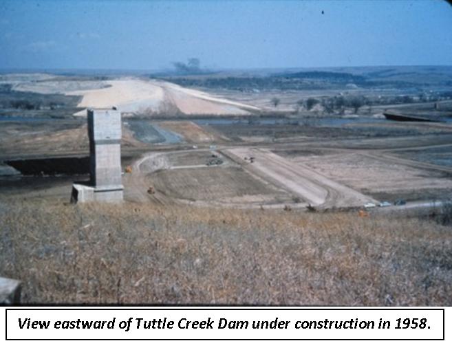
Actual construction began on October 7, 1952 and continued through December 1953 when work was suspended due to lack of additional appropriations. Construction work resumed in December 1955. Closure of the dam occurred July 4, 1959; the Big Blue River was diverted to flow through the intake tower with dynamite detonated to simulate an atomic explosion. This operation symbolized the first control of the waters from the vast drainage area of the Big Blue.
The Corps acquired title to 33,847 acres in fee simple. Flowage easements were purchased on an additional 27,376 acres. The Corps negotiated with 1,713 different landowners during the 13 years (1952-1965) it took to procure project lands.
 Beginning in the early 1950s and continuing until after construction was resumed in 1955, vigorous opposition to the project was directed at officials at local, state, and national levels. Three thousand Blue Valley residents were affected by the dam, and the controversy surrounding the decision to build it was intense. Ten towns were affected: Stockdale, Randolph, Winkler, Cleburne, Irving, Blue Rapids, Shroyer, Garrison, Barrett, and Bigelow.
The proponents of the project, however, prevailed. These primarily downstream interests desired flood protection and regulated releases during periods of low flow.
During later phases of construction, local opposition had dwindled to a few landowners who resisted right-of-entry and evacuation until compelled to yield by court order. As prospects of a large lake became apparent, favorable regard for the project grew.
In 1960, Tuttle Creek Dam, still incomplete, experienced its first large inflow. The heaviest statewide average snowfall of record, 46.3 inches, fell in February and March, followed by mild weather March 21-28. The rapid snowmelt caused moderate to heavy flooding on the Big Blue River. The Kansas River stage was reduced almost four feet at Topeka due to Tuttle Creek Dam, which was credited with $15,243,000 in damages prevented during this period. Some 360,000 acre-feet of snowmelt was retained behind the dam with the outlets fully open. Discharges of 29,000 cubic feet per second were made from March 31 through April 10. To this day, these discharges have never been exceeded.
Construction was completed and operation began July 1, 1962. Multipurpose pool, 1075.0 feet above sea level, was attained April 29, 1963. The reservoir was dedicated June 1, 1963. Total cost was $80,051,031, with an expected return of $4.20 on every dollar invested. (To date, Tuttle Creek Lake has prevented over three billion dollars in damages, yielding an actual return of $37.68 on each dollar invested.)
With the dam completed, the focus turned to operation and maintenance of the project. The hydrologic extremes so often witnessed in the valley frequently dictated lake levels. In 1966 an extended period of drought required the lowering of the pool to maintain water flow on the Kansas River and navigation on the Missouri River. The record low elevation of 1060.82 was attained January 4, 1967.
At the other extreme, 1993 stands as the year of the record high pool level. A series of intense rainfalls in the spring and early summer swelled Tuttle Creek Lake from 13,000 to 56,000 acres. The pool crested at elevation 1137.77 on July 23, 1993, almost 63 feet above normal. The Flood of 1993 resulted in the only spillway release in the history of the lake. All eighteen tainter gates were raised four feet during the flood’s peak, releasing a record 60,000 cfs. The roar of the water was audible half a mile away. The gates were closed following three weeks of releases, revealing the transformation of the spillway channel into a canyonland, testament to the incredible eroding power of fast-flowing water.
When Tuttle Creek Dam was designed, there was no recognized need for specific earthquake evaluations of soil structures, and the techniques to perform the evaluations had not yet been developed. Little was known about Kansas earthquakes, but recent advances in earthquake soils engineering and improved knowledge of Midwest earthquakes enabled the Corps to conduct state of the art seismic evaluations, beginning in the late 1980s. They revealed that Tuttle Creek Dam could be significantly damaged to the point of failure after a major earthquake. The probability of an earthquake of the size necessary to damage the dam is very small, but due to the potential consequences, the Corps modified the subsoil structure of the dam to enable it to withstand the maximum probable earthquake. The stabilization consisted of 351 underground concrete walls beneath approximately one mile of the downstream slope of the dam. The final wall was completed August 31, 2009. Each wall is four feet wide, 45 feet long and 60 feet deep.
During an earthquake, the walls will prevent dam failure since the dam will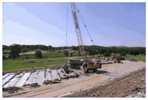 be supported by the walls. The bottom of each wall is founded in strong sand and gravel near the top of bedrock that will not be impacted by shaking.
Restoration of the downstream side of the dam and placement of riprap (large rock protection) on the upstream and downstream slopes of the dam was finished in October, 2010.
The Tuttle Creek foundation stabilization project was completed at a cost of $175 million, $75 million under budget and two years ahead of schedule.
The lake and the policies that govern it are constantly evolving to meet the needs of new generations. Future development and management of the land and water resources at Tuttle Creek Lake is a continuing challenge, a challenge which will be met by the Corps of Engineers.