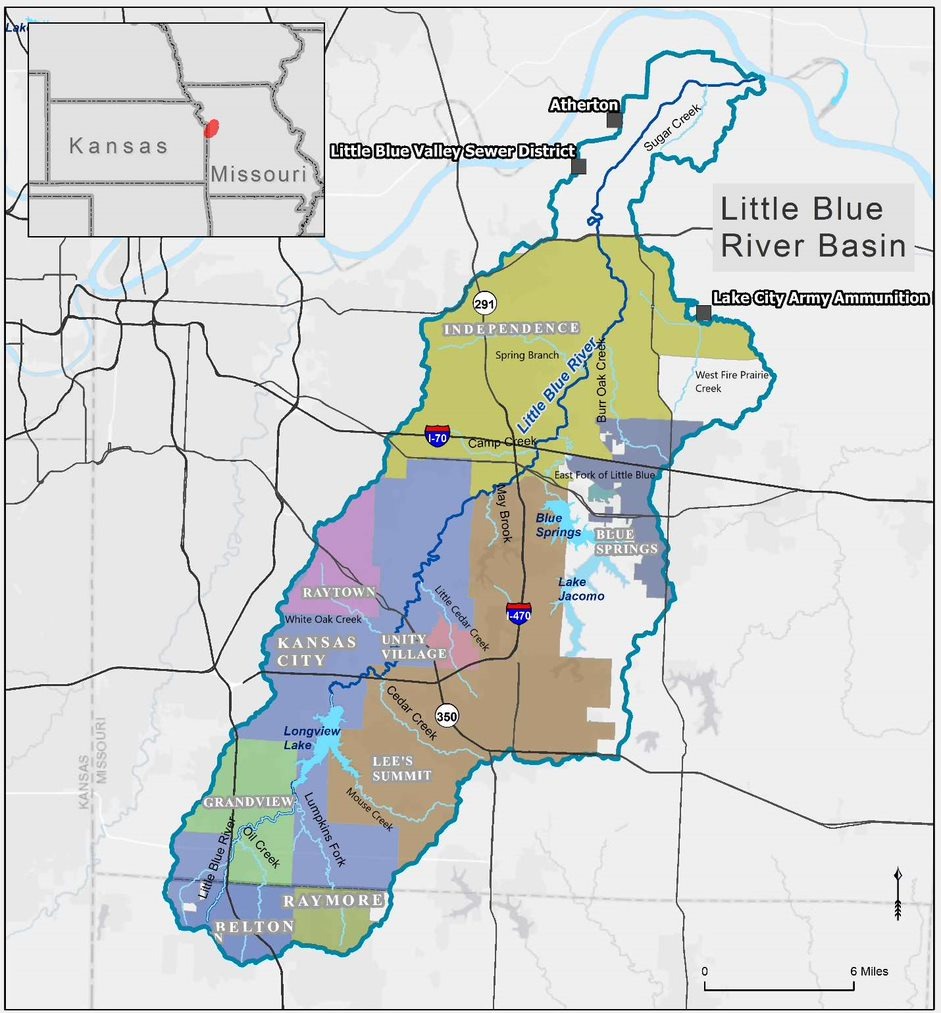
LITTLE BLUE RIVER WATERSHED STUDY


Little Blue River Watershed Flood Risk and Ecosystem Restoration Project General Investigation Study 

Stretching 45 miles through Jackson County, Missouri, the Little Blue River starts south of Longview Lake in Grandview and empties into the Missouri River west of Sibley. Dramatic changes in basin conditions related to urbanization and other factors are causing increased frequency of flooding and rapid erosion that threatens the large federal investment and other significant public infrastructure, as well as the protected communities and installations. 

The flood of record was a ten-inch rainfall on August 12-13, 1982, which caused four fatalities and over $30 million in damages. There have been four flood events in the last 24 years that have exceeded the 2% Annual Exceedance Probability (50-year) flood. If continued unchecked, the adverse effects of the transforming watershed will cause significant deterioration to the federal flood-protection projects, increasing damage to critical infrastructure, wildlife habitat and public recreation investment.

A comprehensive watershed study is required to unite the communities and agencies in the leveraging of resources for the protection of federal investment, infrastructure, habitat conservation, and storm water management allowing for increased economic benefits to the area.


STUDY OBJECTIVES


Study analysis will include formulation and consideration of solutions that will address issues related to flood risk, ecosystem services and other local and regional issues present within the watershed.

Flood Risk Management

- Lowering of flood profiles/damages due to flooding

Ecosystem Restoration

- Habitat connectivity

- Reintroduction of wetland/aquatic habitat

- Address issue of erosion & sediment deposition

Other Beneficial Uses

- Life safety

- Recreation

- Water quality

- Quality of life


ABOUT THE STUDY


What will the study do?

•The objective is to select a plan for USACE implementation that addresses flood risk management and ecosystem restoration. USACE criteria require that the national economic output must be greater than the cost to implement.

•Investigation or planning studies conducted by USACE are distinguished by breadth and depth of technical analysis and data modeling to compare future without project condition to future with project conditions for proposed implementation alternatives.

•The current study will assess the full scope of current conditions and, through modeling, develop planning assumptions for a 50-year time horizon that can be used to inform future decision making by political jurisdictions throughout the basin. The district will share the models developed through the study with the partners for their on-going use once the study is completed.

•More than 50 years have passed since the last USACE planning study. Following the 1966 study, municipalities and Jackson County discussed the creation of a coordination committee because there was a recognition of the need to collectively manage the watershed’s benefits. This study will provide an opportunity for further collaboration among the municipalities and county.

What will the study not do?

•Completion of the study does not guarantee a construction authorization or funding for design and implementation. As noted above, recommendations must meet strict economic cost to benefit ratios.

•While the study will provide valuable insight into broader floodplain and watershed management issues, the study will not prescribe local actions. However, it should also be noted that certain USACE recommendations, if accepted, authorized, and appropriated, to require participating communities to adopt floodplain management plans.

What will happen after the study is completed?

•Based on the final selected plan, recommendations in the plan that meet cost-benefit criteria would move on to design and implementation with additional Congressional authorization and appropriation of funding.

•Using existing authorities, USACE can provide technical assistance to address issues relating to flood risk management, ecosystem restoration, recreation, streambank stabilization.

•By sharing the 50-year future without project assumptions and associated modeling, local governments will be equipped for making informed internal decisions. They will also be equipped to work collectively to build a more resilient Little Blue River Watershed basin.

•When this study ends, communities and organizations within the basin will have a roadmap for future action.


OUR PARNTERS